


Why LIDAR is Transforming Smart City Traffic Management
Smart city initiatives increasingly focus on intelligent transport systems (ITS). A recent pilot in San Francisco using LIDAR sensors demonstrates how this technology can enhance the city’s Vision Zero traffic signal project.
Vision Zero aims to reduce road fatalities to zero, with San Francisco losing roughly 30 lives and injuring over 200 annually. The pilot tests multimodal intelligent traffic signal systems (MMITSS), dedicated short‑range communication (DSRC), transit signal priority (TSP), and emergency vehicle preemption (EVP) to give priority to transit and emergency vehicles while also providing pedestrians and cyclists with safe crossing intervals.
The first proof‑of‑concept, completed in January 2020, installed LIDAR at five intersections and achieved 96 % accuracy in anonymous vehicle and pedestrian profiling. The second PoC is adding the data layer to the signal‑control network, slated for early 2021.
We interviewed Quanergy’s chief marketing officer Enzo Signore and independent strategy consultant Paul Hoekstra, the SFMTA project lead.
LIDAR: Anonymous Object Tracking Across Intersections
Enzo Signore of Quanergy explains that LIDAR’s key advantage in stadiums and smart cities is its ability to assign a persistent, anonymous ID to each moving object, enabling end‑to‑end tracking across multiple intersections without revealing identities.
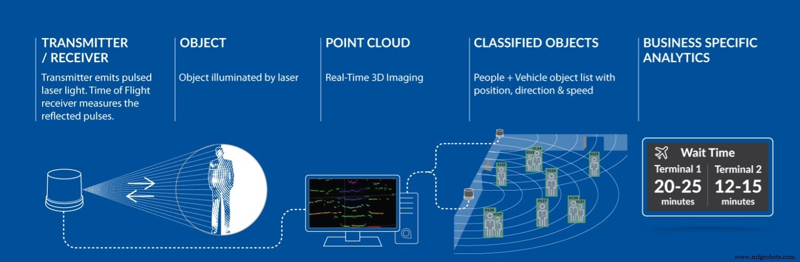
Achieving continuous ID tracking across multiple intersections requires synchronized sensors and edge computing. Traditional systems lose the ID when an object crosses from one sensor’s view to another, fragmenting the data stream.
Quanergy’s automated ID handover mechanism transfers an object’s ID seamlessly between sensors, preserving a single identifier throughout its journey and delivering comprehensive flow analytics.
Quanergy’s M‑Series, including the long‑range MQ‑8, are engineered for flow‑management tasks. Unlike conventional LIDAR that emits a symmetric beam, the MQ‑8 directs all beams downward, ensuring complete ground coverage and eliminating blind spots. This design yields a 70 m detection radius (15,000 m²) and reduces the number of required sensors and cost.
Because LIDAR captures only geometric data, it sidesteps facial‑recognition privacy concerns, providing anonymous, compliant traffic monitoring.
Overcoming Privacy Issues Related to Facial Recognition
Paul Hoekstra for SFMTA describes the project’s rationale and outcomes.
When we began the pilot in April 2019 with SFMTA, Cisco, and Quanergy, we initially used DSRC sensors. However, only 1 % of vehicles broadcast DSRC signals, rendering the technology ineffective for traffic‑flow measurement.
We deployed 20 LIDAR units at five intersections along 3rd Street, near the new basketball stadium. Edge computing ran on Cisco TRX units, executing Quanergy’s QORTEX software, which streams data to a Cisco Kinetic‑powered VM cluster that stores ~30 million messages weekly.
Sunday reports detail vehicle trajectories, timestamps, origins, destinations, stop counts, durations, speeds, and event context. This linkage across intersections allows us to quantify movements such as northbound entries and turn‑offs.
Using QORTEX’s calibrated logic, we achieved 96 % accuracy in matching ingress and egress IDs. For pedestrians, zone definitions reveal kerb presence, crosswalk boundaries, and proximity to vehicles, enabling near‑miss analysis based on vectors and velocities.
The system captures only anonymous shapes—vehicles as blocks and pedestrians as dots—ensuring no personal data is stored.
The first PoC focused on data analysis. The second PoC will double the intersection count from five to ten, extending the corridor scope.
We are integrating the signal‑controller data—loops, pushbuttons, rail sensors—into the central platform, creating a bidirectional information flow. Object classification from edge sensors informs predicted transit dwell times based on passenger composition (wheelchairs, strollers, bikes).
Backend analytics will estimate optimal dwell times (e.g., 20 s vs. 32 s) and extrapolate across the full corridor.
Optimizing the corridor requires viewing it as an interconnected network rather than isolated nodes. High‑frequency algorithmic recalculations—potentially exceeding 1 Hz—enable real‑time signal adjustments.
These algorithms feed real‑time commands to signal controllers, completing the loop and exemplifying integrated traffic management.
San Francisco already hosts 7,000 cameras, but they provide only 2D imagery and less precise location data. LIDAR offers superior accuracy, operates in rain and at night, and avoids privacy concerns tied to visual identification.
The project aims to give emergency vehicles priority, optimize transit schedules, and facilitate vehicle platooning when public transit is unavailable, thereby improving corridor efficiency.
Sensor
- A Practical Taxonomy for Industrial Internet of Things (IIoT) Systems
- Container 4.0: Revolutionizing Maritime Food Transport with Smart Sensors
- Connected LED Streetlights: The Next Step Toward Smart City IoT
- Blaize & LeiShen Partner to Fuse Lidar and AI for Safer Autonomous Driving & Smart City Solutions
- Why Standing Work Orders Streamline Maintenance Management
- Smart Cities: Leveraging 5G, IoT, and Fiber for a Net‑Zero Future
- Secure Linux Solutions for the Intelligent Edge: Expert Webinar
- 5-Year Deadline: Accelerating Enterprise Adoption of Intelligent Systems
- Innovative Color‑Changing Photonic Crystals: The Future of Smart Sensor Technology
- Efficient IoT Sensor Provisioning: Secure Connectivity & Credential Management