


Quanergy’s LiDAR Qortex Platform Enhances Occupancy Management and Social Distancing
Quanergy, a leader in 3‑D lidar technology, has launched the Qortex Flow Management platform—an AI‑driven solution that monitors people flow, enforces occupancy limits, and flags individuals with elevated body temperatures.
Recognized with the Pandemic Tech Innovation Award in 2020, Quanergy pivoted its flagship technology to meet the urgent demand for reliable social‑distancing tools. Today, the platform is deployed in retail, airports, factories, and public transport to keep crowds at safe distances.
LiDAR (Light Detection and Ranging) operates by pulsing low‑power lasers and timing their return. By measuring the time of flight, the sensor calculates precise 3‑D positions and depths, generating rich point clouds that reveal moving objects in real time.
“With lidar, we can instantly determine the distance to any object, then build a full 3‑D picture,” explains Enzo Signore, Quanergy’s Chief Marketing Officer. “The sensor emits light both vertically and horizontally; the returned data is converted into a 3‑D image that identifies, classifies, and tracks people and vehicles.”
Originally focused on autonomous vehicles, Quanergy quickly discovered that lidar’s versatility extended to smart cities, industrial automation, security, and mapping. “We now provide not only the hardware but a complete software platform that unlocks sophisticated applications,” says Signore.
Security is a major advantage: lidar dramatically reduces false alarms, cuts costs by more than five‑fold per coverage area, and delivers accuracy that surpasses camera‑based systems. Unlike cameras, lidar does not capture facial details, eliminating privacy concerns.
How LiDAR Works
The core formula is simple: distance = (speed of light × time of flight) ÷ 2. The sensor measures the round‑trip time, then converts it into elevation data. Key components include a GPS unit for X,Y,Z positioning and an IMU for orientation. Reflections from surfaces—branches, ground, or mirrors—create complex waveforms that the sensor interprets into a 3‑D point cloud.
While similar to radar, lidar uses light rather than radio waves, allowing it to produce a full 3‑D representation of the environment. Performance is quantified by horizontal and vertical field of view, pulse rate, and target reflectivity. For example, white surfaces reflect more light than black ones, affecting detection range.
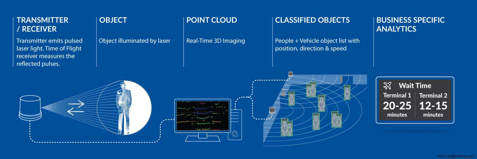
Figure 1: Quanergy lidar technology. (Click to enlarge.)
Quanergy distinguishes itself through exceptionally dense point clouds—up to 1.3 million pulses per second—providing unparalleled detail. Coupled with the Qortex perception software, the system can identify people, vehicles, and background objects, calculate distances, speeds, and trajectories, and enforce social‑distancing thresholds with 95‑98 % accuracy under any lighting condition.
With a single M‑Series sensor, you can cover up to 15,000 m² and detect objects at 70 m with 95 % accuracy—far surpassing the coverage of a hundred cameras. The S‑Series, built on optical‑phased‑array technology, offers vibration immunity and a mean time between failures exceeding 100,000 hours.
Qortex Platform
The Qortex Flow Management platform fuses lidar sensors with AI to provide real‑time people counting, object detection, classification, tracking, monitoring, and social‑distancing analytics. Integrated thermal cameras identify high‑temperature individuals, all while preserving privacy—no personal data is stored or transmitted.
Deployment requires careful sensor placement to avoid occlusions such as columns. Figure 2 shows the M‑Series lidar’s coverage and field of view.
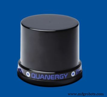
Figure 2: M‑Series of Quanergy
The Qortex People Counter, a patent‑pending solution, pairs the S3‑2 solid‑state lidar with Qortex perception software. Machine learning and 3‑D perception algorithms analyze the point cloud, delivering anonymous real‑time data on crowd density and movement.
Qortex DTC (Detect, Track, Classify) serves as the platform’s brain, generating detailed data on position, direction, speed, and object type. Its API allows integrators and developers to build custom analytics and automation workflows.
When individuals approach too closely or crowds exceed limits, the system issues alerts that can trigger staff interventions or automated controls. Combined with thermal imaging, it offers a comprehensive, privacy‑preserving solution for hospitals, schools, stadiums, and more.
>> This article was originally published on our sister site, EE Times.
Sensor
- Laser Diodes: The Backbone of Motion Sensing and LiDAR Technology
- Maxim’s Advanced LiDAR Module Enables 15 km/h Faster Autonomous Highway Driving
- BlueNRG‑Tile Reference Design Enables Real‑Time Proximity Detection for Contact Tracing
- GreenWaves and Lynred Unveil Low‑Power AI Platform for Precise Building Occupancy Monitoring
- AEye Unveils Long‑Range LiDAR Detecting Vehicles Up to 1,000 m for Autonomous Vehicles
- Arduino-Based Social Distancing Reminder System for COVID-19
- Building an Arduino LIDAR System with VL6180X and Servo Motor
- New Dual‑Chip Detector Achieves Ultra‑Fast Measurement of Quantum Light
- Gold-Enabled 2D Crystal Platform for Next-Gen Quantum Technologies
- Detecting Red Lights on PLCnext with OpenCV and Python